

The Route 20 South Landfill Visioning Committee voted unanimously Feb. 17 to advance a concept plan that centers on a regulation-size grass athletic field, an informal open space, a future trailhead connection, and designated areas for school bus parking and Department of Public Works materials handling on the former landfill on the southbound side of Route 20.
The committee was created in 2020 to recommend future use of the roughly 17-acre town-owned site across from Alta Oxbow and the transfer facility near the Sudbury town line.
Chair Tom Fay noted that the committee’s term ends Feb. 26 and their advisory report was due to the Select Board. He then introduced Ed Shoucair, principal of The Collaborative, an urban planning and design firm. His firm has been working jointly with Weston & Sampson as the engineering consultants.
Shoucair described the site as two parcels totaling about 16.55 acres. Parcel 1, approximately 10.65 acres to the east, includes about 4.5 acres of wetlands. Parcel 2, about 5.9 acres to the west, was originally excavated for gravel before landfill material from the eastern portion was used to fill the resulting cavity. The entire site was capped in accordance with Massachusetts Department of Environmental Protection regulations in place in 1972.
Shoucair said the landfill cap includes several feet of soil and that the town has worked with MassDEP to confirm the cap remains intact. He said the site sits adjacent to the Great Meadows National Wildlife Refuge and near a former rail corridor where the Department of Conservation and Recreation has proposed a future shared-use path.
The committee had previously brainstormed 17 potential reuse options ranging from conservation and passive recreation to housing, commercial development, a town gateway concept, solar generation, dog park, amphitheater, bus parking, DPW materials handling and a wastewater leaching field.
Shoucair said the highest-priority community need identified during interviews and background research was housing, including starter homes, housing for older residents and supported housing for youth with disabilities. He said the team explored whether housing could be built on the capped landfill, including techniques used in other states.
MassDEP indicated that housing would require removal and off-site disposal of underlying landfill material. On the eastern portion of the landfill, DPW director Tom Holder reported that the depth of the waste was “within a few feet” of the surface while on the westerly portion, the depth of waste exceeded about 15 feet in some areas and Weston & Sampson could provide more precise figures later. Shoucair said that removal cost was deemed prohibitive, and the housing concept was dropped.
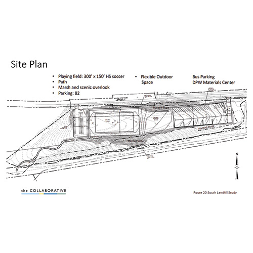
The concept presented on Feb. 17 places a 300-by-150-foot grass athletic field on the wider western portion of the site, with a 30-foot apron along the sides and a 45-foot apron at each end. Shoucair said the field would not include lights. He said up to 82 parking spaces are shown to serve the field and trail access.
An accessible path designed to meet ADA grade requirements would descend from the parking area toward the future DCR trail corridor. An overlook area is proposed near the top of the slope for wildlife viewing and passive enjoyment. Between the athletic field and eastern operational uses, the plan includes a flexible open space intended for informal activities and as a buffer.
On the eastern side, the concept shows an area for school bus parking and DPW materials handling with access from Route 20. Shoucair said the design stays outside both the 100-foot wetland buffer and flood zone, and includes planted slopes for screening and habitat value.
Shoucair said costs were only estimates in part because stormwater management design for the larger impervious surfaces on the eastern side requires additional engineering. He said runoff from the bus and materials area would need on-site detention and treatment before discharge.
During public comment, Tom Sciacca, the town’s representative to the Wild and Scenic River Stewardship Council and a member of the Energy and Climate Committee, said he supports bus parking and long-term planning for electric charging capability.
He cautioned that any solar installations must be evaluated carefully to protect the “wild and scenic character” of the Sudbury River corridor, referencing prior town efforts to limit visual impacts in other projects. Shoucair said solar and charging could be studied further in design development but were not shown in the current concept.
Addressing multiple residents’ concerns, Shoucair said construction would follow best practices to limit ecological disturbance, and that irrigation and stormwater runoff would be managed on site to avoid nutrient loading and water quality impacts. The stormwater controls would be designed to protect the wetlands and the river.
Holder said recent stormwater infrastructure at the COA community center provided an example of best management practices, including subsurface collection and filtration systems, that could inform this project.
During discussion of the draft report to be submitted to the Select Board, committee members agreed to streamline the document to focus on the recommended core uses — the athletic field, flexible open space, trailhead access, bus parking and DPW materials handling — while addressing other ideas, such as solar or boat access, as considerations rather than primary program elements.
Project cost of $5.04 million
The committee met on Feb. 24 to discuss the finalization of a draft report and added a probable project cost of $5.04 million, estimated by Weston and Sampson for the conceptual layout. They discussed the potential benefits and costs of maintaining the land, including the need for periodic mowing and the possibility of renting out sports fields to offset costs. The report will be submitted to the Select Board, with a presentation scheduled for March 9.
To see the full report, visit tinyurl.com/wayland-landfill.
Landfill group proposal includes athletic field, bus parking, and more


Latest from Blog

Winter brings increase in deer–car accidents
By Veronica Hernandez As deer collisions rise during the winter, some Wayland residents are concerned about wildlife and public safety.While it might appear there are more deer-vs.-car accidents, Acting Police Chief Mark

Major changes coming for Wayland schools
School Committee members and the Wayland Public Schools administrative team met with HMFH Architects at the committee’s Feb. 25 meeting to review the culmination of the Wayland PS PK-8 Facilities Planning report

Former Wayland resident Hays to retire as Regis president
By Marina McAlpine After four decades of service and 15 years as president, Antoinette M. Hays will retire from Regis College on June 30, 2026, concluding a tenure marked by sweeping academic

What I’ve learned road-tripping in an electric vehicle
By Michele (Shelley) Trucksis When people learn that I drive an electric vehicle, one of the first questions they ask is, “But what about long trips?” Closely followed by, “Don’t you worry

Broomstones alum takes silver
Korey Dropkin, who trained at Broomstones Curling Club in Wayland, stands with his silver medal with the Dolomites in the background. (Photo courtesy Korey Dropkin)

Community Calendar
Saturday, March 71–4:30 p.m.Mosaic Heart or Jewelry WorkshopAmy Marks Studio (111 Riverview Road, Waltham)Take a break from the everyday and spend an inspiring afternoon creating art with Arts Wayland member Amy Marks.

Public Safety Log
Monday, Feb. 1610:50 a.m. — A Ravine Road resident reported that water in her basement had set off an alarm. The Fire Department provided a pump to remove the water.11:18 a.m. —

Conservation Commission considers Dudley Road area projects
The Conservation Commission on Feb. 11 continued, approved, and deferred multiple projects near Dudley Pond while also discussing Town Meeting articles and municipal pesticide policy.Chair Sean Fair and the commission continued to

Planning Board extends Carroll School decision deadline to April 17
The Planning Board continued its public hearing on the Carroll School site plan application for 37–45 Waltham Road and voted to extend its written decision deadline to April 17 in order to
The 20 properties that help pay Wayland’s bills
Every fall, as the Select Board sets the tax rate, thousands of property tax bills quietly power nearly every public service in Wayland, from classroom lights to plowed roads.For fiscal year 2026,